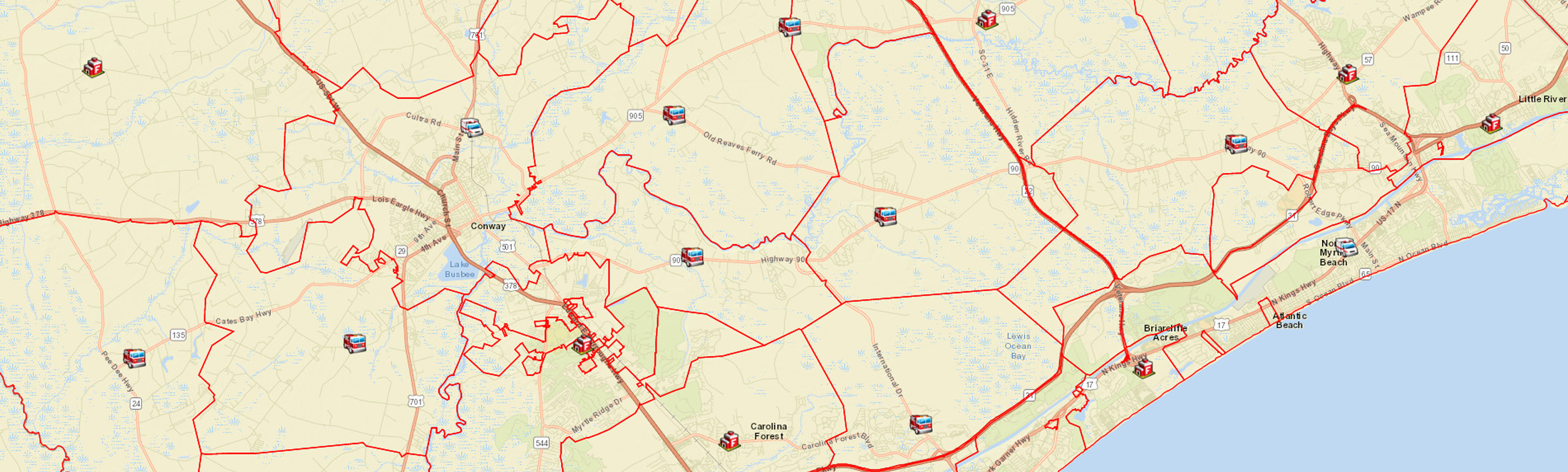
Station Map
This map is of all Horry County Fire Rescue Stations and the fire coverage area. The information listed is the Station Number, Name and Address. Also available is a outline of the station coverage area. Please Click on the Legend to see Station Types.
| Administration | 2560 North Main Street |
| Station 01 – Socastee | 5083 LaFon Lane |
| Station 02 – Little River | 4371 Baker Street |
| Station 03 – Bucksport | 7657 Highway 701 South |
| Station 04 – Forestbrook | 20 Burcale Rd |
| Station 06 – Finklea | 3421 Highway 917 |
| Station 07 – Lake Arrowhead | 10228 Kings Road |
| Station 08 – Juniper Bay | 6700 Juniper Bay Road |
| Station 09 – Antioch | 1235 Highway 129 |
| Station 10 – Ketchuptown | 8131 Highway 917 |
| Station 12 – Hand | 2291 Hwy 31 |
| Station 13 – Longs | 801 Highway 9 West |
| Station 14 – Shell | 4886 Hwy 905 |
| Station 15 – Bayboro | 4368 South Green Sea Road |
| Station 16 – Cates Bay | 6711 Cates Bay Road |
| Station 17 – Mt. Vernon | 2865 Highway 348 |
| Station 18 – Stephens Crossroads | 107 Highway 57 North |
| Station 19 – Cherry Hill | 2501 Cherry Hill Road |
| Station 20 – Scipio | 9620 Scipio Lane |
| Station 21 – Maple | 5443 Highway 65 |
| Station 23 – University | 1589 Highway 544 |
| Station 24 – Aynor | 670 Jordanville Rd. |
| Station 25 – Mt. Olive | 5527 Highway 9 |
| Station 26 – Goretown | 365 Liberty Church Road |
| Station 27 – Allens | 2501 Bay Water Drive |
| Station 28 – Joyner | 4207 Joyner Swamp Road |
| Station 29 – Conway | 704 Country Club Drive |
| Station 30 – Myrtle Beach | 1201 21st Avenue North |
| Station 31 – Surfside | 829 Pine Street |
| Station 32 – North Myrtle Beach | 1002 6th Avenue South |
| Station 34 – Red Bluff | 7552 South Highway 905 |
| Station 35 – Loris | 3815 Walnut Street |
| Station 36 – South Myrtle Beach | 2180 South Kings Highway |
| Station 38 – Floyds | 7412 Highway 9 |
| Station 39 – Carolina Forest | 671 Carolina Forest Boulevard |
| Station 40 – Hickory Grove | 3316 Old Reaves Ferry Road |
| Station 41 – Iron Springs | 2930 Fair Bluff Highway |
| Station 43 – Lees Landing | 2215 Highway 90 |
| Station 44 – Training Center | 1386 State Hwy 67, Loris, SC 29569 |
| Station 45 – Carolina Bays | 790 International Drive |
| Station 46 – Pitch Landing | 1720 Pitch Landing Road |